Estimating aboveground biomass dynamics of wheat at small spatial scale by integrating crop growth and radiative transfer models with satellite remote sensing data
Abstract
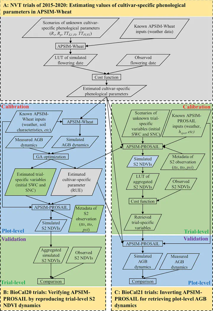
Aboveground biomass (AGB) of plants is an agroecological indicator that can be used to monitor crop growth status and quantify biomass carbon stock in agricultural ecosystems. Although satellite remote sensing data and crop models are widely employed to estimate AGB dynamics, their application in small-scale research plots is often constrained by the unavailability of freely and timely high-resolution satellite imageries and the challenge of acquiring reliable model inputs like initial soil water and nitrogen content. This study integrated a crop growth model (APSIM-Wheat) and radiative transfer model (PROSAIL) to estimate AGB dynamics at a small plot scale (ca. 5 to 20 m2) within variety trials (ca. 1 to 2 ha) by assimilating trial-level remote sensing data into the hybrid APSIM-PROSAIL model. The APSIM-PROSAIL integration, developed by deriving PROSAIL input parameters from APSIM-Wheat output variables, was verified by evaluating its capacity to reproduce trial-level Sentinel-2 (S2) NDVI dynamics across 30 variety trials in 2020. The comparison of the simulated and observed trial-level S2 NDVI dynamics yielded an overall RRMSE of 18.2% (n = 646 observations), suggesting the potential of using observed S2 NDVI dynamics to constrain APSIM-PROSAIL and estimate environment variables in cropping systems. This constraint was subsequently assessed in 28 variety trials in 2021, where APSIM-PROSAIL inversely estimated unknown trial-specific variables including initial soil water and nitrogen content across the trials. Using the estimated initial soil status and the plot information including genotypes and management as sown, we demonstrated that this method could also facilitate accurate retrievals of plot-level AGB dynamics with an overall RRMSE of 20.9% (n = 976 measurements). The proposed APSIM-PROSAIL demonstrated the capability to accurately retrieve plot-level AGB dynamics and reproduce trial-level S2 NDVI dynamics across a broad and diverse range of variety trials in the Australian Wheatbelt, indicating its potential utility to facilitate biomass carbon stock assessment. It holds the potential as a tool to explore the relationships between canopy spectral information and crop traits in response to genotype-environment-management interactions in agricultural ecosystems. The method enables the examinations of within-field variabilities for crop traits through retrieving them at small spatial scales from coarse remote sensing data.
Bangyou Zheng
Data Scientist / Digital Agronomist
a research scientist of digital agriculture at the CSIRO.