Comparison of Modelling Strategies to Estimate Phenotypic Values from an Unmanned Aerial Vehicle with Spectral and Temporal Vegetation Indexes
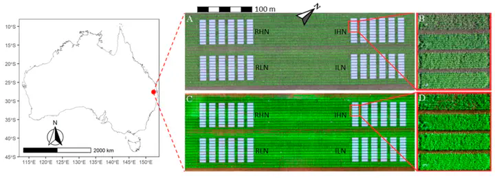 Ortho-mosaics, reconstructed from visible and multi-spectral images captured by UAV
Abstract
Aboveground dry weight (AGDW) and leaf area index (LAI) are indicators of crop growth status and grain yield as affected by interactions of genotype, environment, and management. Unmanned aerial vehicle (UAV) based remote sensing provides cost-effective and non-destructive methods for the high-throughput phenotyping of crop traits (e.g., AGDW and LAI) through the integration of UAV-derived vegetation indexes (VIs) with statistical models. However, the effects of different modelling strategies that use different dataset compositions of explanatory variables (i.e., combinations of sources and temporal combinations of the VI datasets) on estimates of AGDW and LAI have rarely been evaluated. In this study, we evaluated the effects of three sources of VIs (visible, spectral, and combined) and three types of temporal combinations of the VI datasets (mono-, multi-, and full-temporal) on estimates of AGDW and LAI. The VIs were derived from visible (RGB) and multi-spectral imageries, which were acquired by a UAV-based platform over a wheat trial at five sampling dates before flowering. Partial least squares regression models were built with different modelling strategies to estimate AGDW and LAI at each prediction date. The results showed that models built with the three sources of mono-temporal VIs obtained similar performances for estimating AGDW (RRMSE = 11.86% to 15.80% for visible, 10.25% to 16.70% for spectral, and 10.25% to 16.70% for combined VIs) and LAI (RRMSE = 13.30% to 22.56% for visible, 12.04% to 22.85% for spectral, and 13.45% to 22.85% for combined VIs) across prediction dates. Mono-temporal models built with visible VIs outperformed the other two sources of VIs in general. Models built with mono-temporal VIs generally obtained better estimates than models with multi- and full-temporal VIs. The results suggested that the use of UAV-derived visible VIs can be an alternative to multi-spectral VIs for high-throughput and in-season estimates of AGDW and LAI. The combination of modelling strategies that used mono-temporal datasets and a self-calibration method demonstrated the potential for in-season estimates of AGDW and LAI (RRMSE normally less than 15%) in breeding or agronomy trials.
Bangyou Zheng
Data Scientist / Digital Agronomist
a research scientist of digital agriculture at the CSIRO.